The Chango Glacier lies high up in northeastern Kinnaur in the Indian state of Himachal Pradesh. The explorer and mountaineer Marco Pallis was the first outsider to gaze down upon its riches in 1933. He had come up from the village of Nako and ascended to the west col of Leo Pargial. He wrote this – “The western col enjoys a marvelous view to the northward, towards the head of the glacier which flows down towards Chango. This is surrounded by an array of peaks both snowy and of the Chamonix Aiguille type. I can imagine nothing better than a season’s climbing with a base camp well up on the Chango glacier. There is an abundance of suitable sites and every variety of climb within easy reach.”
I was so fascinated by that sentence and by an article in the Indian Mountaineer by Romesh Bhattacharjee that I visited the Chango Glacier three times – in 1993, 1995 and 1998. That translated to actually spending almost three months cumulatively camped on the glacier and trying to explore and climb some of the peaks which appealed to me. I wrote about each of those trips in three blog posts with the heading The Chango Chronicles. Here are the links : https://taccidental.blogspot.com/2014/01/the-chango-chronicles-1993-first.html https://taccidental.blogspot.com/2014/01/the-chango-chronicles-1995-grip-on.html https://taccidental.blogspot.com/2014/02/the-chango-chronicles-1998-third-time.html
Not much was achieved on the 1993 trip due to atrocious weather conditions and a lack of understanding of the true nature of the glacier, the difficulty of the peaks and our own shortcomings. However I did come back with a wealth of first hand knowledge and a huge stock of photos that would come in useful for the subsequent trips. I returned in 1995 and was part of a small team that set their eyes on the real prize of the Chango glacier : a rock monolith which we referred to as “Granite Peak”. More than Leo Pargial, this is the peak that dominates the head of the glacier, rising in a sheer sweep of dark and forbidding cliffs. Seen in silhouette it resembled Batman, the caped crusader of comic book fame and exudes an aura of power and menace. The attempt fizzled out a little less than halfway up the route that we had decided on. The climbing was exhilarating when the small weather window actually permitted us and once again our physical and mental resources were tested to the limit. There was a tremendous sense of disappointment when Harsha and I had to rappel off the route after two testing bivouacs on the mountain. And yet there was a feeling of satisfaction that we had taken on a tough assignment and had made some headway and also lived to tell the tale!
The expedition in 1998 reinforced that old adage : Third Time Lucky. With Arun Samant as the leader of another small team, we achieved the First Ascents of two previously unclimbed peaks as well as the first ascent of Leo Pargial from the Chango glacier. Wisely, I did not even consider re-attempting Granite Peak! It was a happy and satisfying mountain trip where the stars seemed to have aligned perfectly in spite of a few minor hiccups. One of the things that had bothered me for almost three decades is the lack of access to accurate topographical maps of the area from the Survey of India. These maps come under the Restricted category and hence are not available to ordinary mortals like yours truly. I had relied only on the information gleaned from the few expeditions that had been to the Chango glacier via their reports in The Himalayan Journal or the Indian Mountaineer. The only confirmed height was that of Leo Pargial at 6791m. Everything else was conjecture and wishful thinking.
Is the true height of a Himalayan peak really all that big a deal? While one can argue that height alone is not a measure of the real challenge that a peak presents to its suitors, it is a nice thing for the climber to know. Altitude brings perspective. For years I wondered about the true heights of the summits that we had climbed or attempted and for years they remained elusive. Then Google Earth Pro came to my rescue! Or so I thought. For the past few months I have been zooming in to the Chango Glacier from every angle, the cursor hovering minutely over the peaks that I am so familiar with from having seen them up close and personal. One thing became apparent : Though Google Earth Pro does have utilitarian value for the curious, it is not infallible – at least in the version that is available for the average user.
A little over a month ago Ramadi Yaacoub surprised me with a very good rendition of a map that he had created after reading The Chango Chronicles. He lives in Lebanon and I made his acquaintance via Facebook and I was quite tickled by the fact someone I don’t know and have never met took the trouble to read my blog posts and was so intrigued that he applied his mind to create this wonderful art :

After much thought and mulling over my journal entries and photos, I have come to the conclusion that some of the heights of the peaks on Google Earth agree more or less with those shown on the map above while Google Earth is way off the mark on Granite Peak (which it shows at 6065m). Also curious is the fact that Pk 6303m does not appear at all on Google Earth! The height of Ninjeri is also erroneous on Google Earth. I did carry a wristwatch altimeter during all the three expeditions to Chango, the last one in 1998 being the rather reliable one manufactured by Suunto .
Here is a screenshot from Google Earth where I have put the names of the peaks as we referred to them. Other than Leo Pargial, the summits of this glacier had no names until Yousuf Zaheer suggested “Ningmari” and “Ninjeri”, the two peaks whose First Ascents were accomplished by his teams during two different trips.

Google Earth is pretty accurate in showing the height of Leo Pargial (6791m). It is the highest peak of the Chango Glacier and its surveyed elevation is a well known fact. The peak has been climbed many times and does not present any technical difficulties by its standard route. There are many other interesting lines on this magnificent peak but unfortunately they have never been attempted. Access to the west col is fairly straightforward from the village of Nako and this is the way most teams have approached the mountain.
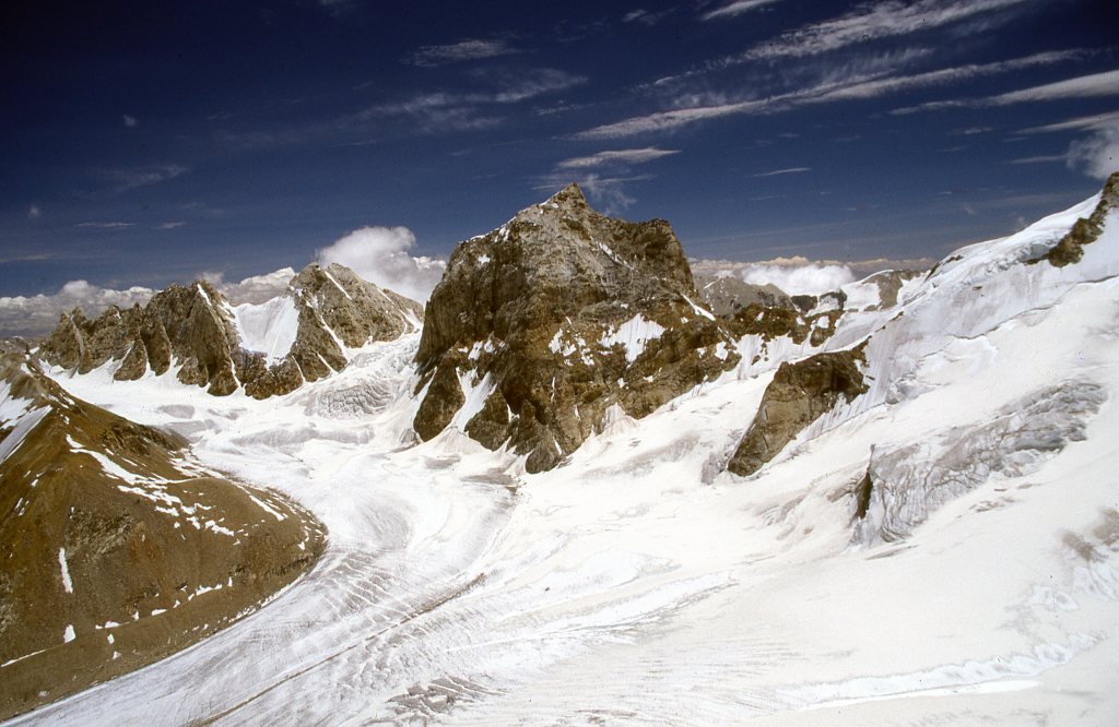
The height of Granite Peak has been estimated at around 6585m based on its relative position to Leo Pargial and Ninjeri, both peaks which have been climbed and thus their altitudes fairly accurate. On Google Earth Pro I could get the precise location of the summit of Granite Peak : 31 deg 55′ 39.49″N 78 deg 45’51.95″E and the mouse cursor indicated an elevation of just 6065m! This is patently absurd. Here is a photo taken from the summit of First Right (climbed in 1998) looking straight at Granite Peak. I was looking at it horizontally when I took this picture and there is no way that it was 200 meters lower than my viewpoint – around 6484m. In fact, it does appear to be at least a hundred meters higher, which only confirms its estimated height at around 6585m

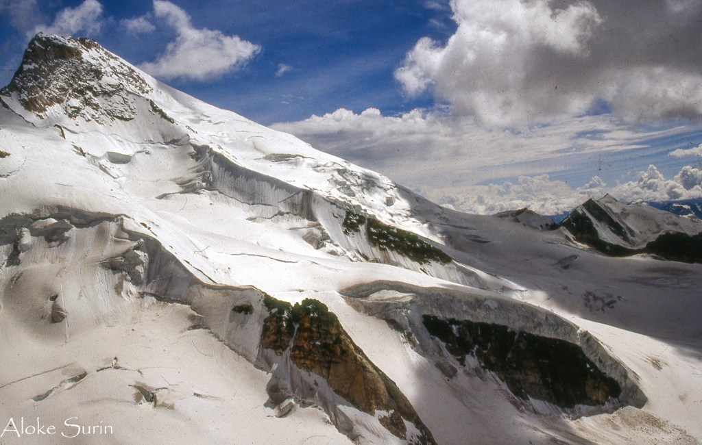
A little over a week later Ravi Wadaskar and I made the first ascent of Corner Peak whose elevation seems to agree with that shown on Google Earth and confirmed by us with our altimeter on the climb. The picture below of Granite Peak from the summit of Corner Peak also suggests that the former is certainly higher than the latter and is in the same league as Ninjeri (6645m) on the extreme left.

I would like to think that the time I spent on the glacier over these three trips has helped me better understand the terrain and the complexity of the peaks and their ridges as well as the little sub-glaciers that together make up this fascinating area of Kinnaur.
I shall endevor in my subsequent posts to recapture the flavor and spirit of those expeditions with the advantage of hindsight and a fuller understanding of the glacier thanks to modern satellite imagery.

Aloke Surin,you have truly demonstrated the spirit of mountaineering through your extensive documentation of the Chango Glacier region and your undying passion for mountainscapes.
The lust for notching up an ascent of the big name peaks versus the grit required to scale unnamed and unclimbed peaks especially on a shoestring budget expedition,is unmatchable.
Your documentation especially the fine art qualityof your photographs,will certainly come of use to climbers new to the Chango region.
It’s time for you to revisit Chango,if I dare suggest !
LikeLike
Thank you so much for your kind words, Anil. Yes, the thought of revisiting the Chango Glacier has actually occurred to me many times! Perhaps its time to set the wheels in motion!!
LikeLike
Dear Aloke, I have gone through the latest write up on Chango Cronicles revisited. With this, I could freshen up our golden days memories of 31 days stay above Chango Glacier Base Camp. It was a great experience. I need at least some of my climbing photos on Corner Peak 6228 meters and of course summit photo on both, snow & rocky summuts. Could you please send to me by email or WhatsApp. My WhatsApp number is 9969015880.
Warm regards,
Ravi Wadaskar
LikeLike