2 – Delights of the Dyke
![]()
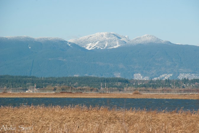
Francis Road was deserted early that morning at the end of January 2001 as I headed west at the break of dawn. The air was cold and crisp, my exhaled breath forming small clouds of fog before my face. Walking a few hundred yards brought me to the West Dyke, a raised bank of earth beyond which lay the wide open expanse of the Georgia Strait which separated Richmond and the rest of the Lower Mainland from Vancouver island whose shadowy hills defined the soft horizon.
Turning left, I began to jog slowly on the gravel track on the dyke towards Garry Point, a couple of kilometers away, reveling in the sense of space and the feel of the chilly air against my skin. The approximately 2.5 km to Garry Point was a great introduction to the delights that I was to discover over the next few years on and off the dyke trails of Richmond.
Margaret, Sanal and I had arrived at Vancouver International Airport on 26th January as Landed Immigrants full of anticipation and curiosity – for details on that story, see : http://taccidentalimmigrant.blogspot.ca/2012/07/welcome-to-canada.html

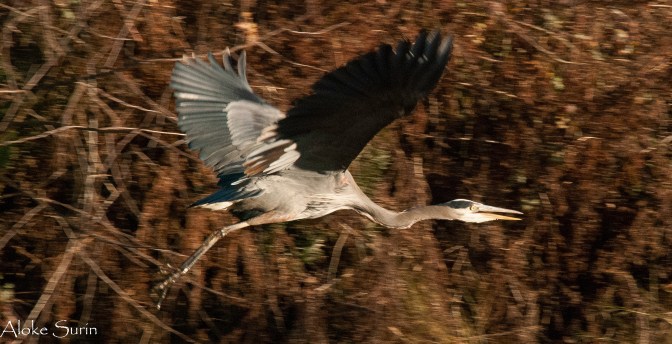
We lived close to the West Dyke for 6 years and in that time I was privileged to witness some spectacular sunsets, double rainbows, nesting bald eagles, sharp shinned hawks, Great Blue Herons, turtles, the occasional grass snake, red winged blackbirds and hundreds of people walking and jogging and cycling . Once, on a cold winter morning, I stopped to chat with Leonard, a mature retiree who would cycle religiously for miles every day on the dyke trails. With his breath condensing into small clouds he told me how once he and his buddy had cycled about 80 km one morning!
Since Richmond is basically a bog that was settled for agriculture, the low lying area had to be protected by dykes to prevent it flooding by the waters of the Strait of Georgia and the south and middle arms of the Fraser river which effectively makes it an island – in fact there is a sign on the west side of Russ Baker Way at the east end of the runway at YVR (Vancouver’s airport) which proudly proclaims : “Richmond – Island City by Nature”!
On the other side of Russ Baker Way, before the new campus of BCIT (British Columbia Institute of Technology) was built, were empty fields where coyotes used to roam freely in the early 2000s!

On the south side of the Middle Arm of the Fraser, you can watch the float planes land and take off. This corner, where the river flows into the Strait, is very popular with Richmond residents. One year, I watched a spectacular display by migrating snow geese here. Even more intriguing birds like the Hooded Merganser hide in the reeds along the waterways of the Terra Nova Nature Park nearby.
The areas bordering the dykes – especially the one in West Richmond – have undergone great changes in the last 15 years, with new houses creeping ever closer to the edges. Change has been less drastic on the dykes bordering the south end of Richmond, where the quaint little settlement of Finn Slough is situated.
Finn Slough, as the name suggests, was primarily settled by people from Finland. Over the decades though the constituents have become quite mixed. Two years ago I met a woman who lives in a picturesque shack who was from Quebec but had spent a lifetime traipsing around the world. Finn Slough appeals to the free spirited and the unconventional. The downside of this is that every weekend tourists and painters and photographers come to gawk at the dilapidated structures in a kind of (in their view) artistic homage!
Further east, the road along the dyke affords extensive views across the broad expanse of the river. Anglers sit in their chairs and fish all weekend long while cormorants and herons and the occasional bald eagle look for meals in the water. On a clear winter day, the massive bulk of Mount Baker, a hundred kilometers away, soars more than 10,700 feet into the blue sky. Runners and cyclists flash by in groups, practicing for various competitions, while massive container ships move slowly upriver to their unloading docks further upstream.The waters lap gently on the shore, giving life to the ebb and flow of life, and stir the tall grass on the banks before serenity settles once more on the Dykes of Richmond.


Beautiful.. enjoyed reading this Aloke.. I would love to walk the Dykes of Richmond as well one day… one day.
LikeLiked by 1 person
Thank you Christine, the next time you guys come here we shall take you there!
LikeLike